1/16
Spain Topo Maps screenshot 0
Spain Topo Maps screenshot 1
Spain Topo Maps screenshot 2
Spain Topo Maps screenshot 3
Spain Topo Maps screenshot 4
Spain Topo Maps screenshot 5
Spain Topo Maps screenshot 6
Spain Topo Maps screenshot 7
Spain Topo Maps screenshot 8
Spain Topo Maps screenshot 9
Spain Topo Maps screenshot 10
Spain Topo Maps screenshot 11
Spain Topo Maps screenshot 12
Spain Topo Maps screenshot 13
Spain Topo Maps screenshot 14
Spain Topo Maps screenshot 15
Spain Topo Maps Icon

Spain Topo Maps

ATLOGIS Geoinformatics GmbH & Co. KG
Trustable Ranking Iconယံုၾကည္ရေသာ
1K+ေဒါင္းလုဒ္မ်ား
15.5MBအရြယ္အစား
Android Version Icon5.1+
Android ဗားရှင်း
7.2.0(12-01-2024)နောက်ဆုံး ဗားရှင်း
4.0
(1 ျပန္လည္သံုးသပ္မႈမ်ား)
Age ratingPEGI-3
ထည့္သြင္းပံု
1
ထည့္သြင္းရမည့္ဖိုင္ကို ေဒါင္းလုဒ္ဆြဲကာ ဖြင့္ပါ
2
Unblock AptoideAptoide is a safe app! Just tap on More details and then on Install anyway.
3
ထည့္သြင္းမႈကို ၿပီးေအာင္လုပ္ကာ Aptoide ကိုဖြင့္ပါ
app-card-icon
အေသးစိတ္မ်ားျပန္လည္သံုးသပ္မႈမ်ားဗားရွင္းမ်ားအချက်အလက်
1/16

၏ ရွင္းလင္းခ်က္ Spain Topo Maps

+++ New GPS Mapping App +++


Easy to use Outdoor/Offline GPS navigation app with access to the best topographic maps and aerial images for Spain.


Including Balearic Islands and Canary Islands


++ For offline use PRO features needed ! ++


Turn your Andoid Phone/Tablet into an outdoor GPS for trips into the backcountry WITHOUT CELL COVERAGE. This app gives you similar mapping options as you might know from GPS handhelds.


Included FREE map layers:


• Spain Topo Map: Mapa Topográfico Nacional 1:50.000 & 1:25.000 (IGN MTN25 & MTN50)

• IGN Base Map: Base Topográfica Nacional 1:25.000 (BTN25 & BCN25)

• Spain Imagery: High resolution aerial imagery. Plan Nacional de Ortofotografía Aérea (PNOA)

• Catalonia Topo Maps: High resolution topographic maps for Catalonia

• Land Register Map: Cartografía Catastral

• OpenStreetMaps : These crowdsourced maps are a very useful addition to other map layers. Contains many unique features.

• OpenCycleMaps: These maps are ideal to plan bicycle trips

• ESRI Topographic

• ESRI Aerial Images

• ESRI Street Map

• Google Road Map (online access only)

• Google Satellite Images (online access only)

• Google Terrain Map (online access only)

• Bing Road Map (online access only)

• Bing Satellite Images (online access only)

• Earth At Night

• Hillshading overlay


Main features for outdoor-navigation:


• Create and edit Waypoints

• GoTo-Waypoint-Navigation

• Track Recording (with speed, elevation and accuracy profile)

• Tripmaster with fields for odometer, average speed, bearing, elevation, etc.

• GPX/KML/KMZ Export

• Search (placenames, POIs, streets)

• Customizable datafields in Map View and Tripmaster (e.g. Speed, Distance, Compass, ...)

• Share Waypoints, Tracks or Routes (via eMail, Whatsapp, Dropbox, Facebook, ..)

• Display coordinates in Lat/Lon, UTM or MGRS/USNG (Military Grid/ US National Grid)

• Record & share tracks with statistics & elevation profile

• Rotate map (Track Up & North Up)

• Get Elevation by long click on map

• Track Replay

• and many more ...


Available Pro features: (Pro features available via In App Purchase)


• Offline Use - no cell coverage needed

• Easy+Fast Bulk-download of map tiles for OFFLINE USAGE (not for Google and Bing maps)

• Create and edit Routes

• Route-Navigation (Point-to-Point Navigation)

• GPX/KML/KMZ Import

• unlimited Waypoints & Tracks

• Add other Map Tile-Server

• No Ads


Offline Use:

All viewed map tiles are kept in cache. To cache large areas you need to purchase Pro features.


Use this navigation app for outdoor activities like hiking, biking, camping, climbing, riding, skiing, canoeing, hunting, offroad 4WD tours or search&rescue (SAR).


Add custom waypoints in longitude/latitude, UTM or MGRS/USNG format with WGS84 datum.


Import/Export/Share GPS-Waypoints/Tracks/Routes in GPX or Google Earth KML/KMZ format.


Preload FREE map data for areas without cell service (Pro feature !).


Comments and feature requests to spainmaps@atlogis.com


Have a look at our other outdoor navigation apps: https://play.google.com/store/search?q=atlogis


+++ We DO NOT track any user activities or collect any user data ! +++

+++ နယူးဂျီပီအက်စ်မြေပုံ App ကို +++


စပိန်အတွက်အကောင်းဆုံးမြေမျက်နှာသွင်ပြင်မြေပုံနှင့်ဝေဟင်ပုံရိပ်တွေမှဝင်ရောက်ခွင့်နှင့်အတူအော့ဖလိုင်း / အဆောက်အဦးအပြင်ဂျီပီအက်စ်အညွှန်း app ကိုအသုံးပြုရလွယ်ကူတယ်။


Balearic ကျွန်းများနှင့်ကိန္နရီကျွန်းများအပါအဝင်


++ လိုအပ်အော့ဖ်လိုင်းအသုံးပြုမှု PRO features တွေသည်! ++


ဆဲလျလွှမ်းခြုံမရှိဘဲ backcountry သို့ခရီးစဉ်များအတွက်တစ်ဦးပြင်ပတွင်ဂျီပီအက်စ်သို့သင့်ရဲ့ Andoid ဖုန်း / Tablet ကိုဖွင့်။ သငျသညျ GPS စနစ်လက်ကိုင်ကနေကိုသိစေခြင်းငှါ, အဖြစ်ဒီ app ကိုသင်အလားတူမြေပုံ options များပေးသည်။


ပါဝင်သည်အခမဲ့မြေပုံအလွှာ:


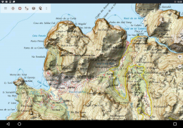
•စပိန် Topo မြေပုံ: Mapa Topográfico Nacional 1: 50,000 & 1: 25.000 (IGN MTN25 & MTN50)

• IGN အခြေစိုက်စခန်းမြေပုံ: အခြေစိုက်Topográfica Nacional 1: 25.000 (BTN25 & BCN25)

•စပိန်ပုံရိပ်: အမြင့် resolution ကိုဝေဟင်ပုံရိပ်။ Plan ကို Nacional de OrtofotografíaAérea (PNOA)

• Catalonia Topo Maps ကို: အမြင့် resolution ကို Catalonia များအတွက်မြေမျက်နှာသွင်ပြင်မြေပုံ

•မြေမှတ်ပုံတင်မည်မြေပုံ: Cartografía Catastral

• OpenStreetMap: ဤ crowdsourced မြေပုံနဲ့အခြားမြေပုံအလွှာတစ်ခုအပြင်နောက်ထပ်အလွန်အသုံးဝင်ဖြစ်ကြသည်။ အများအပြားထူးခြားသော features တွေပါရှိသည်။

• OpenCycleMaps: ဤမြေပုံစက်ဘီးခရီးစဉ်စီစဉ်ရန်စံပြများမှာ

ESRI မြေမျက်နှာသွင်ပြင်•

ESRI ဝေဟင်ပုံများ•

ESRI လမ်းမြေပုံ•

• Google မှလမ်းမကြီးမြေပုံ (သာအွန်လိုင်းလက်လှမ်း)

• Google မှဂြိုဟ်တုပုံရိပ်များ (သာအွန်လိုင်းလက်လှမ်း)

• Google မှမြေမျက်နှာသွင်ပြင်မြေပုံ (သာအွန်လိုင်းလက်လှမ်း)

• Bing မှလမ်းမကြီးမြေပုံ (သာအွန်လိုင်းလက်လှမ်း)

• Bing မှဂြိုဟ်တုပုံရိပ်များ (သာအွန်လိုင်းလက်လှမ်း)

•ညမှာကမ္ဘာမြေ

• Hillshading ပြသမှု


ပြင်ပ-အညွှန်းများအတွက်အဓိကအင်္ဂါရပ်များ:


•အမှတ်များ ဖန်တီး. တည်းဖြတ်

• Goto-အမှတ်-Navigation

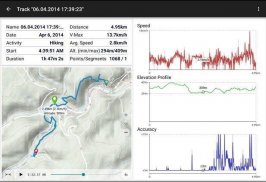
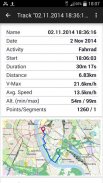
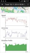
• (အမြန်နှုန်း, မြင့်နှင့်တိကျမှန်ကန်မှုကိုပရိုဖိုင်းနှင့်အတူ) Track ကိုမှတ်တမ်းတင်ရန်

•စသည်တို့ကို odometer ပျမ်းမျှအမြန်နှုန်း, bearing, မြင့်များအတွက်လယ်ကွင်းတွေနဲ့ Tripmaster

• GPX / KML / KMZ ပို့ကုန်

•ရှာရန် (PLACENAME, မှန်မှန်, လမ်းများ)

မြေပုံကြည့်ရန်နှင့် Tripmaster (ဥပမာမြန်နှုန်း, အဝေးသင်, သံလိုက်အိမ်မြှောင်, ... ) ထဲမှာ•စိတ်ကြိုက် datafields

•ဝေမျှမယ်အမှတ်များ, သီချင်းများသို့မဟုတ်လမ်းကြောင်းများ (အီးမေးလ်ကနေတဆင့်, Whatsapp Dropbox, Facebook က, .. )

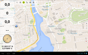
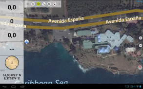
• Display ကိုလတ် / လုံ, UTM သို့မဟုတ် MGRS / USNG (စစ်ရေး Grid / အမေရိကန်အမျိုးသား Grid) တွင်သြဒိနိတ်

•စာရင်းဇယား & မြင့်ကိုယ်ရေးအကျဉ်းကိုနှင့်အတူမှတ်တမ်း & ရှယ်ယာပုဒ်

•လှည့်မြေပုံ (Track Up ကို & မြောက်အမေရိက Up ကို)

•မြေပုံပေါ်တွင်ရှည်လျားကလစ်နှိပ်ခြင်းဖြင့်မြင့်တက် Get

• Track ပြန်ဖွင့်

•အများအပြားကပို ...


ရရှိနိုင် Pro ကိုအင်္ဂါရပ်တွေ: (ခုနှစ်တွင် App ကိုဝယ်ယူခြင်းကနေတဆင့်ရရှိနိုင် Pro ကို features တွေ)


•အော့ဖ်လိုင်းဖြင့်အသုံးပြုပါ - မပါဆဲလ်လွှမ်းခြုံလိုအပ်

•လွယ်ကူ + (မ Google နှင့် Bing မှမြေပုံများအတွက်) အော့ဖ်လိုင်းအသုံးပြုမှုများအတွက်မြေပုံကွက်များအမြန်အစုလိုက်-download,

• Create နှင့်ပြင်ဆင်ရန်လမ်းကြောင်းများ

•လမ်းကြောင်း-Navigation (Point-to-Point သို့ Navigation)

• GPX / KML / KMZ သွင်းကုန်

•န့်အသတ်အမှတ် & သီချင်းများ

•အခြားအမြေပုံ Tile-Server ကို Add

•အဘယ်သူမျှမကြော်ငြာ


အော့ဖ်လိုင်းအသုံးပြုမှု:

အားလုံးကြည့်ရှုအားပေးမြေပုံကွက် cache ထဲတွင်ပြသလျက်ရှိသည်။ သငျသညျ Pro ကို features တွေဝယ်ယူရန်လိုအပ်ပါတယ်ကြီးမားသောဒေသများသိုလှောရန်။


ဒီအညွှန်း app ကိုတောင်တက်စီးခြင်း, စက်ဘီးစီးခြင်းစခန်းတောင်တက်, စီးခြင်း, နှင်းလျှောစီး, canoeing, မုဆိုး, offroad 4WD ခရီးစဉ်သို့မဟုတ်ရှာဖွေ & ကယ်ဆယ်ရေး (SAR) ကဲ့သို့သောပြင်ပလှုပ်ရှားမှုများများအတွက်သုံးပါ။


WGS84 datum နှင့်အတူလောင်ဂျီတွဒ် / လတ္တီ, UTM သို့မဟုတ် MGRS / USNG format နဲ့ထုံးစံအမှတ်များထည့်ပါ။


GPX သို့မဟုတ် Google Earth KML / KMZ format နဲ့ Import / Export / ဝေမျှမယ် GPS စနစ်-အမှတ်များ / သီချင်းများ / လမ်းကြောင်းများ။


ဆဲလ်ဝန်ဆောင်မှု (Pro ကိုအင်္ဂါရပ်!) မပါဘဲဒေသများများအတွက်အခမဲ့မြေပုံဒေတာကြိုတင်ထား။


spainmaps@atlogis.com မှမှတ်ချက်များနှင့်အင်္ဂါရပ်တောင်းဆိုမှုများ


ကျွန်တော်တို့ရဲ့အခြားပြင်ပအညွှန်း app များကိုကြည့်ရှိသည်: https://play.google.com/store/search?q=atlogis


+++ ကျနော်တို့ကိုမဆိုအသုံးပြုသူလှုပ်ရှားမှုများကိုခြေရာခံသို့မဟုတ်မည်သည့် user data ကိုစုဆောင်းဘူး! +++


Spain Topo Maps - ဗားရွင္း 7.2.0

(12-01-2024)
အျခား ဗားရွင္းမ်ား
ဘာအသစ္ရွိလဲ• Improvements & Fixes

သုံးသပ္ခ်က္ သို႔မဟုတ္ အဆင့္သတ္မွတ္ခ်က္မ်ား မရွိေသးပါ။ ပထမဆုံး ျပဳလုပ္ရန္အတြက္ ကို ထည့္သြင္းေပးပါ။

-
1 Reviews
5
4
3
2
1
Info Trust Icon
ေကာင္းမြန္ေသာအက္ပ္ျဖစ္ေၾကာင္း အာမခံသည္ဤအက္ပ္သည္ ဗိုင္းရပ္စ္၊ ေမးလ္၀ဲႏွင့္ အျခားမသမာေသာ တိုက္ခိုက္မႈမ်ားအတြက္ လံုၿခံဳေရးစစ္ေဆးခ်က္ကို ေအာင္ျမင္ခဲ့ၿပီး မည္သည့္အႏၲရာယ္မွ် မရွိပါ။

Spain Topo Maps - APK သတင္းအခ်က္အလက္

APK ဗားရွင္း: 7.2.0package: com.atlogis.spain
အန္းဒ႐ိုက္ ကိုက္ညီမႈ: 5.1+ (Lollipop)
ထုတ္လုပ္သူ:ATLOGIS Geoinformatics GmbH & Co. KGကိုယ္ေရးလံုၿခံဳမႈ မူ၀ါဒ:http://www.atlogis.com/Atlogis_Privacy_Policy.pdfခြင့္ျပဳခ်က္မ်ား:21
အမည္: Spain Topo Mapsအရြယ္အစား: 15.5 MBေဒါင္းလုဒ္မ်ား: 704ဗားရွင္း : 7.2.0ျဖန္႔ခ်ိသည့္ ရက္စြဲ: 2024-03-21 09:46:19စခရင္အေသး: SMALLအေထာက္အပံ့ေပးနိုင္ေသာ စီပီယူ:
ပက္ေက့ဂ်္အိုင္ဒီ: com.atlogis.spainSHA1 လက္မွတ္: D8:C6:8E:17:4B:AE:BE:EC:B8:F7:8C:E9:6D:07:66:55:4D:D0:F8:5Cထုတ္လုပ္သူ (CN): Atlogis Geoinformatics oHGအဖြဲ႕အစည္း (O): Atlogis Geoinformatics oHGေဒသဆိုင္ရာ (L): G√ºterslohနိုင္ငံ (C): DEျပည္နယ္/ၿမိဳ႕ေတာ္ (ST): NRW

Spain Topo Maps ၏ ေနာက္ဆုံးဗားရွင္း

7.2.0Trust Icon Versions
12/1/2024
704 ေဒါင္းလုဒ္မ်ား15 MB အရြယ္အစား

အျခား ဗားရွင္းမ်ား

7.1.0Trust Icon Versions
25/10/2023
704 ေဒါင္းလုဒ္မ်ား12.5 MB အရြယ္အစား
7.0.4Trust Icon Versions
19/8/2023
704 ေဒါင္းလုဒ္မ်ား12.5 MB အရြယ္အစား
7.0.3Trust Icon Versions
17/7/2023
704 ေဒါင္းလုဒ္မ်ား12.5 MB အရြယ္အစား
7.0.0Trust Icon Versions
21/3/2023
704 ေဒါင္းလုဒ္မ်ား12.5 MB အရြယ္အစား
6.9.1Trust Icon Versions
20/1/2023
704 ေဒါင္းလုဒ္မ်ား12.5 MB အရြယ္အစား
6.9.0Trust Icon Versions
14/1/2023
704 ေဒါင္းလုဒ္မ်ား12.5 MB အရြယ္အစား
6.8.0Trust Icon Versions
11/7/2022
704 ေဒါင္းလုဒ္မ်ား12 MB အရြယ္အစား
6.7.1Trust Icon Versions
6/12/2021
704 ေဒါင္းလုဒ္မ်ား10.5 MB အရြယ္အစား
6.7.0Trust Icon Versions
20/11/2021
704 ေဒါင္းလုဒ္မ်ား10.5 MB အရြယ္အစား

က႑တူအက္ပ္မ်ား

သင္ႏွစ္သက္ႏိုင္သည္မ်ားမွာ...